Randonnée Marche La Chapelle-des-Pots - Circuit des potiers - La Chapelle des Pots - Photo

Circuit des potiers - La Chapelle des Pots

 tracegps
tracegps

Utilisateur

© OpenStreetMap contributors
Longueur
Longueur
7,2 km
Altitude max
Altitude max
70 m
Dénivelé positif
Dénivelé positif
100 m
Km-Effort
Km-Effort  
8,5 km
Altitude min
Altitude min
35 m
Dénivelé négatif
Dénivelé négatif
99 m
Boucle
Boucle
Oui
Date de création :
2014-12-10 00:00:00.0
Dernière modification :
2014-12-10 00:00:00.0

(0 Avis)

Marche
Marche
2h00
Difficulté : Moyen

Scannez ce code QR pour ouvrir la randonnée dans l'application SityTrail

Application GPS de randonnée GRATUITE

Logo SityTrail SityTrail

IGN / Instituts géographiques

Télécharger SityTrail sur l'App Store Télécharger SityTrail sur Google Play

Logo SityTrail SityTrail World

Le monde est à vous

Télécharger SityTrail sur l'App Store Télécharger SityTrail sur Google Play Télécharger SityTrail sur Huawei AppGallery

À propos

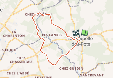
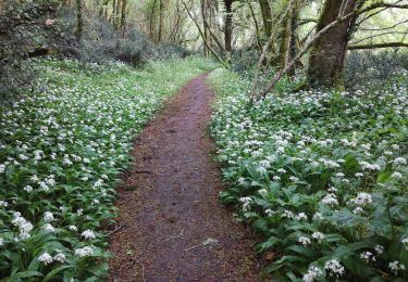
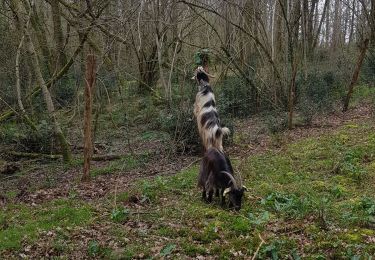
Randonnée Marche de 7,2 km à découvrir à Nouvelle-Aquitaine, Charente-Maritime, La Chapelle-des-Pots. Cette randonnée est proposée par tracegps.

Description

Circuit proposé par la Communauté de Communes du Pays de Santon. Départ de la mairie de La Chapelle-des-Pots. Retrouvez le circuit sur le site de la Communauté de Communes du Pays de Santon.

Profil altimétrique

Photos

Localisation

Pays :
France
Région :
Nouvelle-Aquitaine
Département/Province :
Charente-Maritime
Commune :
La Chapelle-des-Pots
Localité :
Unknown
Départ:(Dec)
Départ:(UTM)
691186 ; 5070336 (30T) N.

Randonnées à proximité

Randonnée Cheval La Chapelle-des-Pots - Circuit des potiers - La Chapelle des Pots - Photo
Cheval
tracegps

Cheval

Facile
(1)
La Chapelle-des-Pots, Nouvelle-Aquitaine, Charente-Maritime, France
7,2 km | 8,5 km-effort
1h 19min
Oui
Randonnée Marche La Chapelle-des-Pots - la Chapelle des Pots ( D ROUSSET) - Photo
Marche
Claudinette17

Marche

Moyen
(1)
La Chapelle-des-Pots, Nouvelle-Aquitaine, Charente-Maritime, France
7,8 km | 8,8 km-effort
2h 40min
Oui
Randonnée Marche Chaniers - port huble - Photo
Marche
ninie51

Marche

Moyen
Chaniers, Nouvelle-Aquitaine, Charente-Maritime, France
5,6 km | 6,5 km-effort
1h 39min
Oui
Randonnée Marche La Chapelle-des-Pots - La Chapelle des Pots - Asphodèles - Photo
Marche
Claudinette17

Marche

Facile
(1)
La Chapelle-des-Pots, Nouvelle-Aquitaine, Charente-Maritime, France
7,4 km | 8,7 km-effort
2h 5min
Oui
Randonnée V.T.T. Le Douhet - Circuit des Arches de Fontcouverte - Photo
V.T.T.
tracegps

V.T.T.

Difficile
Le Douhet, Nouvelle-Aquitaine, Charente-Maritime, France
16,5 km | 19,8 km-effort
1h 15min
Oui
Randonnée V.T.T. La Chapelle-des-Pots - Circuit des potiers - La Chapelle des Pots - Photo
V.T.T.
tracegps

V.T.T.

Facile
La Chapelle-des-Pots, Nouvelle-Aquitaine, Charente-Maritime, France
7,2 km | 8,5 km-effort
34min
Oui
Randonnée Marche Saint-Césaire - La Vallée du Coran - St Bris des Bois - Photo
Marche
tracegps

Marche

Moyen
Saint-Césaire, Nouvelle-Aquitaine, Charente-Maritime, France
7,4 km | 8,9 km-effort
2h 0min
Oui
Randonnée Marche Vénérand - venerand - Photo
Marche
jpland17800

Marche

Très difficile
Vénérand, Nouvelle-Aquitaine, Charente-Maritime, France
24 km | 28 km-effort
6h 21min
Non
Randonnée Marche La Chapelle-des-Pots - la chapelle des pots - Photo
Marche
niniroro51

Marche

Moyen
La Chapelle-des-Pots, Nouvelle-Aquitaine, Charente-Maritime, France
5,9 km | 7,1 km-effort
2h 2min
Oui


Fermer
Mes abonnements